On Wednesday morning, Typhoon Mawar was on track to make landfall on Guam. It would be the biggest storm to hit the US island in decades. The National Weather Service office in Guam has warned of a “triple threat” of devastation from the typhoon, which includes devastating winds equivalent to at least a Category 4 hurricane, extraordinary storm surge, and copious rainfall.
According to Guam’s warning coordination meteorologist Landon Aydlett, Mawar will be remembered for decades. On Wednesday afternoon, local time (late Tuesday or early Wednesday, Eastern Time), it is predicted to make a direct hit on the island.
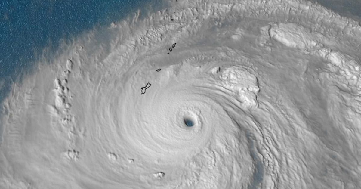
Early Wednesday morning local time, the center of Mawar was 80 miles from Guam, and conditions were rapidly deteriorating as the outer bands of the storm swept through the territory and the heart of the storm approached.
The Joint Typhoon Warning Center reported that as of early Wednesday morning, Mawar’s maximum sustained winds have increased to 140 mph, making it a Category 4 hurricane. Earlier, it had 155 mph winds, making it a super typhoon (which requires winds of at least 150 mph for an extended period of time).
Before making landfall, Mawar was predicted to have sustained winds of above 157 mph, the equivalent of a Category 5 hurricane. Wednesday morning brought the possibility of fluctuations in the storm’s severity, and forecasts predict that it will maintain a high level of intensity as it travels over Guam to the west and northwest over the next few days.
Wednesday morning, the storm’s forward speed dropped to 6 mph. A slower pace would cause the effects of the winds and rain to last longer. “Guam will see devastating impacts from Typhoon Mawar,” the National Weather Service in Guam warned. Typhoon’s fiercest winds and heaviest storm surge would wreak havoc on the island if it makes a direct touchdown.
A direct hit from a storm of this strength is extremely rare, having only occurred roughly eight times in the last 75 years despite Guam’s location in the West Pacific Ocean, which is prone to the world’s fiercest tropical cyclones. The island is only 30 miles long, making passage through the eye of a storm as difficult as threading a needle.
Reading the California Examiner is a great way to ensure that you are up to date on all of the most recent news:
- Key Factors to Consider When Selecting the Right Reverse Mortgage Lender
- “Verified” Twitter Accounts Posted a Fake Picture of a “Explosion” Near Pentagon
The last major storm to strike Guam was Typhoon Pamela in 1976, which brought sustained gusts of 140 mph. Mawar could be even stronger. If Mawar’s sustained winds are higher, it will be the greatest storm to reach the island since Super Typhoon Karen in 1962, which was usually considered the worst storm to ever hit the island with sustained winds of 172 mph.
Climate change triggered by humans is increasing the likelihood of extreme weather events like Typhoon Mawar. These systems are more likely to become stronger and to intensify more quickly, and they are also producing more rainfall and greater storm surge.
Top wind speeds for Mawar increased by 50 mph from Monday to Tuesday, an extremely quick intensification. Scientists have warned that rising ocean temperatures will provide ideal conditions for tropical cyclones like hurricanes and typhoons to rapidly intensify and become catastrophic storms.
Forecasters have cautioned that structures not made of concrete will certainly sustain significant damage when the winds approach Category 5 strength. Strong winds can lift debris and cause extensive damage to roofs, and flying projectiles are always a risk.
Most trees will be snapped or uprooted,” the weather service in Guam warned, and “electricity and water may be unavailable for days or maybe weeks after the storm passes.” Mawar’s gusts might strip the island of as much as 70% of its vegetation.
The following tweet confirms the reports that a monster typhoon is headed for US territory:
In the most susceptible coastal areas near the eyewall, a storm surge of up to 25 feet poses a serious risk to life and property. The National Weather Service reports that the majority of people killed by hurricanes in the United States perished due to storm surge.
The weather agency has warned that “large boats could be torn from moorings” if the storm surge reaches that level. The storm is expected to bring 10–15 inches of rain, with locally higher amounts up to 20 inches likely, which could cause flash floods in addition to coastal flooding from storm surge.
Since the storm is expected to bring more rain to the entire region, a flood watch has been issued. The weather office has cautioned that “higher rainfall totals” are conceivable if the storm’s forward speed decreases. As the earth becomes wet, the soil along mountainous terrain will become unstable, increasing the likelihood of landslides.
If you want to read up on the Golden State as soon as new items are published, bookmark the California Examiner.