


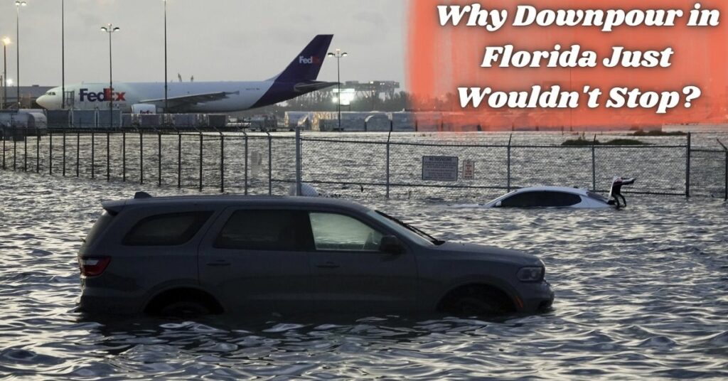
It was like a hurricane version of the Florida Man; it couldn’t decide when to stop. Typically, thunderstorms die off because they run out of moisture or because they draw in the chilly air. This was not the case on Wednesday, however, when the storm that pounded Fort Lauderdale was aided by the proximity of the warm and moisture-rich Gulf Stream.
Within six to eight hours, Fort Lauderdale was drenched and flooded by more than 25 inches (63.5 cm) of rain. According to weather historian Chris Burt, that was the third-highest 24-hour total among major U.S. cities, behind only Hilo, Hawaii’s 27 inches (68.58 centimeters) in 2000 and Port Arthur, Texas’s 26.5 inches (67.31 centimeters) in 2017.
Greg Carbin, chief of the prediction section at the National Oceanic and Atmospheric Administration’s Weather Prediction Center, stated that while it is possible for this to occur in other coastal American states, Florida has the correct geography, plenty of warm water nearby, and other ideal conditions.

Carbin added that just two days prior to the storm, a forecaster named David Roth from the Weather Prediction Center warned his coworkers that conditions were aligning similar to April 25, 1979, when 16 inches of rain (40.64 cm) fell on Fort Lauderdale.
Some meteorologists have confirmed that the storm that lingered over Fort Lauderdale on Wednesday was a supercell, the kind of powerful thunderstorm that can produce deadly tornadoes and hail and drive across the Great Plains and Mid-South in a swift but brief trail of destruction.
Carbin explained that normally a cell like that would “snuff itself out” in about 20 minutes, or at least keep going. However, Carbin noted that the Fort Lauderdale supercell occurred during a break in the action between two separate meteorological systems. Between six and eight hours passed.
Make sure you stay in the know – follow these links for the latest news from the Golden State:
- MMA Fighter Kills Airman Outside Florida Bar
- Florida Death Row Inmate Petitions Supreme Court for Stay of Execution
According to Steve Bowen, chief science officer for the international reinsurance broker GallagherRe and a meteorologist, “you had this extreme warmth and moisture that was just feeding into the cell,” which was “essentially acting like a vacuum” and sucking all that moisture back up into the main core of the system. “Basically, it kept igniting all over again.”
Key was that “the availability of warm ocean air from the Gulf Stream was essentially infinite,” as explained by former NOAA chief scientist Ryan Maue. Maue and Carbin cited a powerful low-pressure system with counterclockwise winds as another contributing cause to the unusually warm conditions in the Gulf of Mexico.
The Florida land was a bit colder than the Gulf Stream waters, which were hovering about 80 degrees. To that, we can add wind shear, which occurs when winds at different altitudes are blowing in opposite directions. The existence of the Gulf Stream, for example, is not unprecedented in and of itself.
However, their precise combination functioned like a never-ending feeding loop, producing rainfall amounts that the Miami National Weather Service estimated had a 1 in 1,000 probability of occurring. “We continue to see more and more of these thousand-year” weather extremes in major cities, Bowen said. “The whole definition of normal is changing.”
According to physical laws, the amount of moisture in the air increases by around 4% for every degree Fahrenheit (7% for every degree Celsius) of temperature increase. However, according to climate scientist Michael Mann of the University of Pennsylvania, warming also increases the strength of storms, which amplifies that level of moisture.
That condensation becomes precipitation. Professor of meteorology at the University of Oklahoma Jason Furtado wrote in an email that one-day downpours have “increased in frequency and magnitude over the last several decades and will continue to increase in both” in the coming decades.
“These heavy rainfall events coupled with sea level rise on the Florida coast need to serve as significant ‘wake up calls’ for the residents of South Florida about the severe risks that climate change poses to them.”
Get up-to-the-minute news and content from the California Examiner – just follow their Twitter handle!