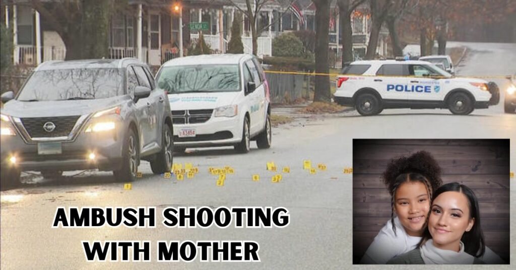
The Region Will Soon Experience Its Biggest Lake-effect Snowfall As Colder Air Continues To “Pour Across” The Area

The lake-effect blizzard that pummeled the Southtowns was forecast to continue through Friday night in the lakeshore and northeast of Lake Erie.

The Buffalo area will experience the most snow at this time, according to the National Weather Service update at 3:10 p.m. on Friday.

The National Weather Service predicted that “Lake snows would then migrate north and west of (Buffalo) Saturday before sliding back southward Saturday night into Sunday, with chilly blustery conditions to finish the weekend and start the new work week.”

Therefore, as the band of lake-effect snow progressively drifts northward, southern Erie County should start to get a break as Buffalo deals with the snow.

People in the county’s southern region are in need of respite.

According to the Erie County Department of Public Works, the Southtowns is “very unsafe” right now. According to a department tweet, hard-packed snow and ice beneath freshly fallen snow are causing the agency’s plows to become stuck.

Read More: Infant’s Death Led To The Arrest And Manslaughter Prosecution Of A Woman

The meteorological service predicted that “colder air will continue to flood across the region, resulting in a significant lake-effect snow extending through this weekend.”

According to Erie County Executive Mark Poloncarz, a travel ban was reinstated earlier on Friday for the City of Buffalo from William Street downtown to the Town of Cheektowaga boundary and everything south.

“Please refrain from entering this region by car. The situation has rapidly deteriorated, “Tweeted he.

At 5 p.m. on Friday, the National Weather Service reported that Orchard Park had received 54 inches of snow, Blasdell and Elma had received 48 inches, and East Aurora had received 41 inches.

Before the storm passes, some places could receive a few more feet of snow.

Southern Erie County might receive an additional foot or 2.5 feet by the time the storm is over on Monday. According to National Weather Service meteorologist Liz Jurkowski, the Niagara County area will receive an extra 8 to 12 inches of rainfall, while the Buffalo area will receive an additional 1 to 2 feet.

The central region of Erie County continues to be under a travel prohibition, and portions of the Thruway, Routes 219, and 400 were blocked due to the snow.

Authorities claim a large number of stranded automobiles in hard-hit locations, particularly Hamburg, notwithstanding the restriction.

Travel ban diagram
Additionally, the Thruway is shut down between Exits 53 (I-190) and 59. (Dunkirk). According to a tweet from the Thruway Authority, no vehicles are allowed to enter between those exits.

For most of the morning, a lake-effect snow band covered southern Erie County, spanning from Chautauqua County’s Lake Erie shoreline to Hamburg, West Seneca, and Attica.

The Weather Service issued a warning: “This lake effect snow band is producing exceptionally heavy snow at a pace of 2 to 3 inches per hour.”

The storm is anticipated to leave behind several feet of snow in some regions as it moves on, perhaps by Sunday morning.

Up until Saturday morning at one o’clock, southern Erie, Wyoming, and Chautauqua counties are under a lake-effect snow warning.

The lake-effect band was expected to hang over the Southtowns and Buffalo for the majority of the day on Friday, according to the National Weather Service.

(National Weather Service) Cheektowaga, Lancaster, Alden, West Seneca, Elma, Marilla, Hamburg, Orchard Park, Aurora, Wales, Evans, Eden, and Boston continue to have driving restrictions in place.

Erie County Executive Mark Poloncarz tweeted, “They have been keeping South Park Avenue, Abbott Road, and other main roads open but it is very bad overall.” Lackawant reportedly declared a state of emergency this morning.

Read More:

About The Author

Scroll to Top