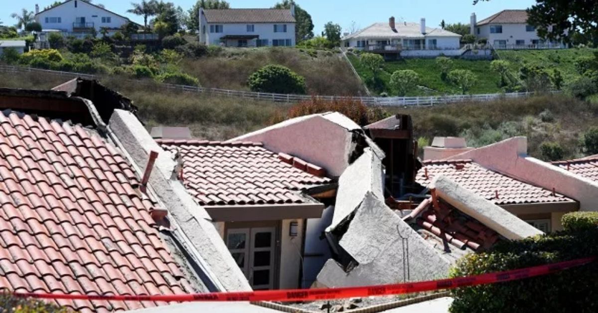
Los Angeles County officials say they were forced to order the evacuation of a dozen homes in a Southern California enclave over the weekend because of shifting ground that put them on a collision course with a neighboring canyon.
Officials with the Los Angeles County Fire Department (LACFD) red-tagged and evacuated 16 individuals from their homes on Peartree Lane in Rolling Hills Estates on Saturday, the city reported. The Los Angeles County Fire Department tweeted a video showing severe damage, including partially collapsed homes and broken ground.
HOMES THREATENED by sliding hillside | FS106 | Pear Tree Ln #RollingHillsEstates | #LACoFD units were on scene monitoring situation. 12 homes evacuated. pic.twitter.com/ruXIhKD82m
— L.A. County Fire Department (@LACoFDPIO) July 9, 2023
According to a statement posted online by the city, Rolling Hills Estates is collaborating with Los Angeles County agencies and the Red Cross to house the evacuees. The city stated it is monitoring the affected region alongside the Los Angeles County Fire Department and the Los Angeles County Sheriff’s Department.
The homes in Los Angeles County have been “pulled off their foundations,” tweeted Los Angeles County Board of Supervisors Chair Janice Hahn on Sunday. Even though the terrain is still shifting, just these 12 households have been told to evacuate.
The tweet below verifies the news:
A dozen homes in the southern California community were evacuated after the ground beneath them shifted, putting them at risk of a collision course into a nearby canyon.https://t.co/mDJRE4aBve
— MSN (@MSN) July 11, 2023
Since Hahn was in the region the day before and saw only a “few cracks” and bent garages, she estimates that the landslide moved the ground roughly 20 feet. Hahn reported that backyard decks and garages were “gone” after they collapsed into the ravine.
I’ve never seen anything like it. Hahn claimed the houses were “completely uninhabitable” and that authorities were waiting for them to collapse into the ravine so they could investigate the reason of the collapse.
According to the USGS and the California Geological Survey, the region of Southern California is prone to landslides due to its placement on a major tectonic plate boundary and its geological complexity. According to USGS, several types of landslides, such as rapid debris flows produced by high rainfall, occur in the region.
Here are some reliable resources to read up on the most recent news chaos:
- Initial Victim Shot in Philadelphia 44 Hours Before Larger Attack, Police Say
- Barracks of California Marine Camp Searched After Missing 14-year-old Girl Located; Marine Arrested
Hahn speculated that the landslide was caused by excessive rains, which then led to subsurface water causing a fissure, which then led to the collapse of the dwellings and their subsequent descent into the canyon. According to Google Maps, Rolling Hills Estates may be found on the northern part of the Palos Verdes Peninsula in Los Angeles County.
The Associated Press reports that in 1956 a landslide buried 140 homes in Rancho Palos Verdes and that the ground is still shifting there. “Luckily, we got everybody out, people were given 20 minutes to get their belongings,” she said. “Everyone was coopering. We’re now here kind of in a recovery mode eventually to see what we can do to help people.”
Peartree Lane is off-limits to everyone save residents, city employees, and emergency personnel, so says the city. Rolling Hills Estates claims that city officials and their partners are looking into the event.
“The outpouring of support from our community has been amazing over these past few days. Not just from within Rolling Hills Estates, but from our neighboring cities and our elected officials at the County and State levels,” Mayor Britt Huff said in a statement on the city’s website.
“It has been truly inspiring to see how everyone is pulling together to offer assistance, especially to our displaced residents and their families.”
If you go to our Facebook page and click the “Like” button, we will be able to communicate with you more regularly and keep you informed.